Five layers of orbital debris response
August 29, 2026
The organizations working on orbital debris are usually solving different problems, not competing for the same one. A tracking provider and an impact sensor serve the same satellite operator for entirely different reasons, in the way that an air traffic controller and a flight recorder serve the same airline.
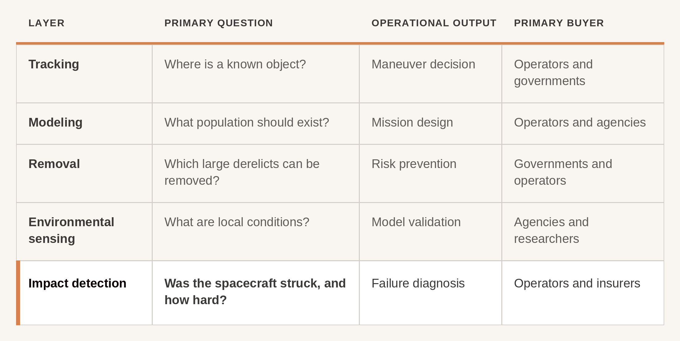
Five layers have emerged, and each answers a different question. Tracking asks where a known object is, and hands operators a maneuver decision. Modeling estimates what population should statistically exist, which is what shapes a mission before it launches. Removal targets the large derelicts that can be eliminated before they fragment. Environmental sensing measures local particle conditions, and that is how the models get validated.
The fifth asks something none of the others can: was this spacecraft struck, and how hard?
That question has an unusual pair of buyers. Operators need it to run a failure investigation. Insurers need it to pay a claim. Everything above serves people trying to avoid a collision; the fifth layer serves people dealing with one that already happened.
Tracking: cataloging known objects
Ground-based radars and optical telescopes observe objects in orbit and maintain catalogs of their positions and predicted paths. Space-surveillance networks currently hold catalog data on roughly 46,000 objects, against an ESA estimate of around 54,000 objects larger than ten centimeters in orbit altogether.
This is the layer everything operational rests on. Every collision-avoidance maneuver a satellite performs traces back to it, and conjunction alerts, the warnings that two objects may pass dangerously close, come from here.
The constraint is size. Detection from the ground depends on altitude and sensor capability, and it falls away quickly below roughly ten centimeters in low Earth orbit. A one-centimeter aluminum fragment at orbital velocity carries enough kinetic energy to destroy a satellite, and it is far too small to catalog reliably. The catalog is comprehensive within its range, and its range excludes most of what can kill you.
Representative organizations include the U.S. Space Force’s 18th Space Defense Squadron, LeoLabs, ExoAnalytic Solutions, Slingshot Aerospace, and, in the emerging space-based surveillance segment, Charter Space.
Models: statistically modeling invisible objects
Because most debris cannot be tracked, the community estimates the population instead. ESA’s MASTER and NASA’s ORDEM ingest data from known fragmentation events and project how many fragments should exist at a given size and altitude. MASTER-8 puts roughly 1.2 million objects between one and ten centimeters in low Earth orbit, and more than 130 million larger than one millimeter.
Mission designers use these models to assess collision probability before launch, and regulators use them for long-term forecasting. But a statistical model predicts populations; it does not diagnose events. It cannot say what is near your specific satellite right now, or what struck it this morning.
The models are also least constrained at exactly the sizes that matter most, because there has never been much measurement to check them against. That gap is where in-situ data feeds back in.
Removal: eliminating large threats before they fragment
Active debris removal goes after large derelicts (dead satellites, spent rocket stages) that pose the greatest long-term fragmentation risk. The logic is upstream prevention. A single derelict in a crowded orbit is a potential source of thousands of new fragments.
It is necessarily limited to objects big enough to rendezvous with and capture. A five-millimeter shard cannot be found, let alone retrieved.
Representative organizations include Astroscale, whose ADRAS-J mission rendezvoused with and inspected a derelict rocket stage before completing operations and beginning its deorbit, and ClearSpace, whose ESA-backed retrieval mission is now targeting the retired PROBA-1 satellite.
Environmental sensing: measuring local conditions
Spacecraft-mounted particle detectors measure the flux of small debris and micrometeoroids in a satellite’s local environment, sampled continuously. The value is validation: localized measurement to check the global statistical averages against.
A detector of this kind may resolve individual particle events, but what it produces operationally is flux, particles per area per time. It characterizes the neighborhood rather than the spacecraft.
Impact detection: measuring the strikes themselves
Most of the ecosystem is oriented around observation at a distance, from the ground or from orbit. Impact detection adds a different sense. Inside Odin the shorthand is blunter: everyone else works on seeing. We make satellites feel.
Sensors mounted on the spacecraft detect and characterize individual strikes from the population researchers call lethal non-trackable debris. Fragments too small to catalog reliably from the ground, large enough to damage or disable a satellite. When a fragment hits, the sensor registers that the impact occurred, where on the structure it happened, and an estimate of its severity.
That event-level record is something neither a population statistic nor a trajectory catalog can produce, and it makes two otherwise impossible things possible.
When a satellite suffers an anomaly, impact data lets an operator separate a debris strike from an internal fault. That is the first branch of any failure investigation, and without evidence it is a guess. Insurers get the same thing from the other side: independent confirmation that a specific external impact occurred, which is what isolates the peril from every other way a satellite can fail.
The research community gains something too. This is a population that individual experiments have sampled, but that has never been watched continuously across the orbits operators actually depend on.
The limits are real. Impact detection requires a sensor on the spacecraft, and it measures only what strikes the instrumented satellite, not what passes nearby. It records events after they occur, so it does not replace conjunction screening. It covers the population sitting below screening’s reach.
What it produces is ground truth. It validates the models where they are weakest, and combined with tracking data it could support attribution linking a measured impact to a probable source. Aggregated across enough spacecraft, event-level data starts to become environment-level data, which is the point of building a network rather than selling instruments.
Odin Space occupies this layer. The Odin Black Box is a compact sensor unit mounted on the host spacecraft, establishing that an external strike occurred, where, and how severe. Odin’s roadmap adds Outpost satellites, dedicated spacecraft carrying the same sensing technology into the orbits of most interest, extending coverage beyond hosted missions. Across the network, those measurements build toward a map of flux, direction, and size, orbit by orbit. Both feed Odin Overwatch, the service through which operators and insurers receive the data.
Why the fifth layer has to exist
The other four all work at a distance from the event itself. Tracking and modeling describe the population. Environmental sensing samples the conditions. Removal thins the population out.
Only instrumentation on the spacecraft can reliably record that the spacecraft itself was struck. Every downstream decision that follows a failure (fleet operations, design changes, an insurance claim) depends on that first fact being established.
The pieces are not new. What is new is their assembly into a connected stack, and an industry starting to treat debris as an engineering problem with engineering answers rather than an unavoidable cost of operating. Odin Space builds the intelligence layer for orbital impact. Contact us to find out more.
Odin Space provides in-orbit impact data and does not underwrite insurance. Collision cover referenced here is underwritten through Lloyd's of London and arranged through the regulated broker WTW.
Sources: ESA Space Debris Office, space environment statistics (2026); ESA MASTER-8 model; NASA Orbital Debris Program Office, ORDEM; Astroscale ADRAS-J mission updates; ESA ClearSpace-1 mission page; U.S. Space Force 18th Space Defense Squadron.